
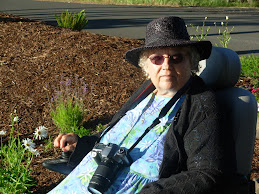
We left home about 1 pm and were on the way to Neah-Kah-Nie Mountain when I took this photo. DeWayne calls this the lightning tree.

A closer view of the same stump.

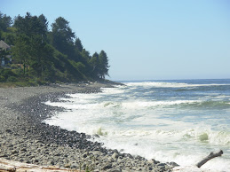
Looking down the coast from Neah-Kah-Nie Mountain. Pirates supposedly buried treasure somewhere on the mountain or beach below and treasure hunters have been looking for it for over 100 years.

Same view with more detail. The town below is Manzanita, an upper-class destination.

Going down the hill into Nehalem. It used to be a fishing and logging town and now it is full of tourist and quilting shops.

A boat on the Nehalem River.

A house boat on the Nehalem. The funny little sign on the side says "No lifeguard on duty"

My step-father, Eino Mickelson, fished on this river as well as on the Columbia River, and in the Bering Sea out of Dillingham, Alaska. We ate a lot of fish when I was growing up--Salmon, Sturgeon and Smelt. I would say "Not fish again!"

This is Wheeler, Oregon taken from the highway near Nehalem. The smoke was someone burning trash, probably trees from the windstorm. We have fires going here constantly. If fact, DeWayne is out burning the needles and branches from a huge pine tree he finished cutting down.

This is the same river, only taken from closer to the mouth, from Wheeler, Oregon. This town is where Eino kept his boat when he was fishing the Nehalem.

The Nehalem River with the coast range behind.

I graduated from here, Neah-Kah-Nie High School, in 1956. I went here for 10th, 11th and 12th grades.

This part on the right is a new addition. Grades 6th through 12th go here now. Hey Michelle, apply for a job here! I think the new gym is in this part. We had PE on the beach once in a while. The football field is to the right.

The library, art room, Biology, Chemistry and Typing all looked out these windows. The school is right across the highway from the ocean and I saw whales spouting as they migrated North in the Spring and South in the Fall. Some whales migrate clear into December.

Hwy 101 runs through the middle of Rockaway Beach, OR and also constitutes its main street. We rented a cabin here when we first moved to the coast in 1946. Rockaway used to have a large heated salt water natatorium right next to the beach where my mother taught me to swim. Condominiums are now located there.

The ocean near Twin Rocks, Oregon, south of Rockaway Beach.

Twin Rocks, OR. My brother Gary had a friend with a boat and one summer his friend took Gary, Jen, and me out into the ocean and really close to the backs of these rocks.


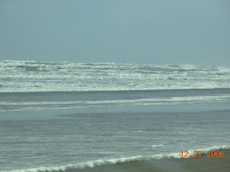
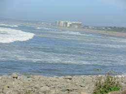
Rough surf at the jetty. No boats were going in and out as the bar was way too rough!

I don't know what the purpose was of this trestle, but it has been there since the 1950's at least. This little section is all that is left.

Two of the three sirens in Barview with the mouth of Tillamook Bay and the Bay Ocean peninsula behind.

Downtown Garibaldi, the little town where I lived from age 7 in second grade until I graduated at age 17 (I skipped the fourth grade).

The house that we lived in--my stepfather, my mother, my brother Kenny, my sister Marcia, my little brother Gary and me. I was nine when Marcia was born and thirteen when Gary was born.

The old sawmill's smoke stack. This is where my step-father worked for many years besides fishing during the different fishing seasons.

Garibaldi from Idaville,(or is it Hobsonville?) partway around Tillamook Bay.

The large building with the gray roof is the old school I went to from 6th through 9th grade.

A view of the "G" (for Garibaldi) on the hill behind town. I climbed it twice during the years we lived there.

You can see the smokestack and how big it is.

The mountain to the left is Cape Meares and the long Bayocean peninsula is what makes Tillamook Bay what it is. Otherwise it would be part of the ocean. In fact, during the 60's or 70's the ocean did break through but men filled the breach with rocks. Bayocean was once a famous resort but the ocean reclaimed it and the buildings fell in. Now it is a park strictly limited to hikers.

This bridge is located on Hwy. 101 on the north end of Tillamook.

One of the two main streets of Tillamok. Both are one-way. Many of the buildings in all of the coastal towns have buildings more than 50 years old. I can't think of a building with more than four stories.

This was known as the Blimp Base during WWII and construction began on it in 1942. It is now an air museum housing several airplanes.

A dairy farm and green pastures to produce that famous Tillamook Cheese. Extra sharp cheddar is my favorite and don't forget those cheese curds!

If you blink you will miss this little town of Hebo south of Tillamook.

Sunset and a beautiful sky that the camera came nowhere close to capturing. We were close to Lincoln City when I took this photo out my passenger window.


4 comments:
Wow mom!!! You captured such beautiful pictures of the drive along the coast. I love the comments and your memories. This kind of blogging is like your own personal journal. Thanks for sharing it with us.
Love, Shelly
Like I said before, this is awesome for the grandkids and future generations to read...What's strange is that I'm old enough to remember going to grandmas house and the "G" on the mountain, it was fun to reminicse with you.
I just love all these photo's it is just beautiful up there:) We should come visit sometime! I love the beach;)
I feel homesick for a home where I wasn't raised but visited. I loved our trips up there and can't wait to come again. I was telling the kids that the next time we go up to your house I want to take a day trip up to Seattle. Wouldn't that be fun!
Post a Comment